Hello my friends
I'm very happy you are visiting!

Hello my friends
I'm very happy you are visiting!
I did a rough budget check and for fourteen days I’ve spent $3777 against a budget of $5138.
So it seems I’m $1361 to the good.
Assuming that I’m back 30 days from departure.
Leaving from Tucumcari tomorrow, that will be day 16.
Not bad.
I think the second two weeks will be more expensive.
_______________________________________
Today is Wednesday, September 19, 2018
This is my 162nd consecutive daily posting.
Time is 3.34am in Tucumcari, NM, and the weather in Dallas, TX is 97 and sunny.
The hot weather of these last few days has not been a problem since most of my driving has been through the hottest times of the days.
Last night I had a T-bone.
It wasn’t bad.
_____________________________________________
My drive eastwards continues.
I’m heading towards Dallas but I don’t know how long I’ll stay on the highway.
This is my first very early departure.
Not planned.
Just going with the flow.
At some point I’ll decide I want to stop driving and then I’ll find a place to stay and to have supper.
_____________________________________________
Don't forget to communicate with me @
domcapossela@hotmail.com.
Tommie Toner did:
(Ed. Note: Her note Is in response to Grand Canyon pix; plus note, Tommie’s terrific husband is Don Toner, not to be confused with Dom, the web-meister.)
Wonderful photos! The place is more than amazing. I loved every minute Don and I were there in the 60's. . . the one place we took the time to stop and look. I would love to spend several days there and take the mules down to the bottom. Had a professor friend to do that and he said it was an amazing adventure. Thanks for sharing.
Web Meister responds: It’s an interesting point. I went to the Grand Canyon to see and marvel at it.
Knowing full well that a hundred possibilities exist for ‘doing’ the site more intensely. The mules. Rafting. Hiking.
We often come away wishing we had done more.
Time.
Interest.
There’s interest, of course. But it doesn’t outweigh other ways we choose to spend our time.
Oh well!
And Richard Engleson did with a caution re: the weather back east and south. My destination.
But not for another five days.
Hopefully things will improve.
Several others also communicated and I will post them tomorrow.
Like the photos of the Grand Canyon, too much of a good thing.
_______________________________________
You are aware I stayed in a Native American village last night.
Today I went to their cultural center and took a tour.
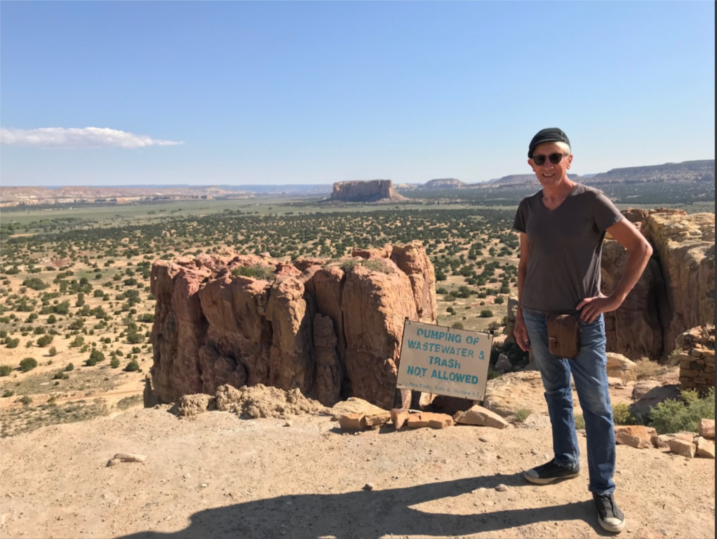
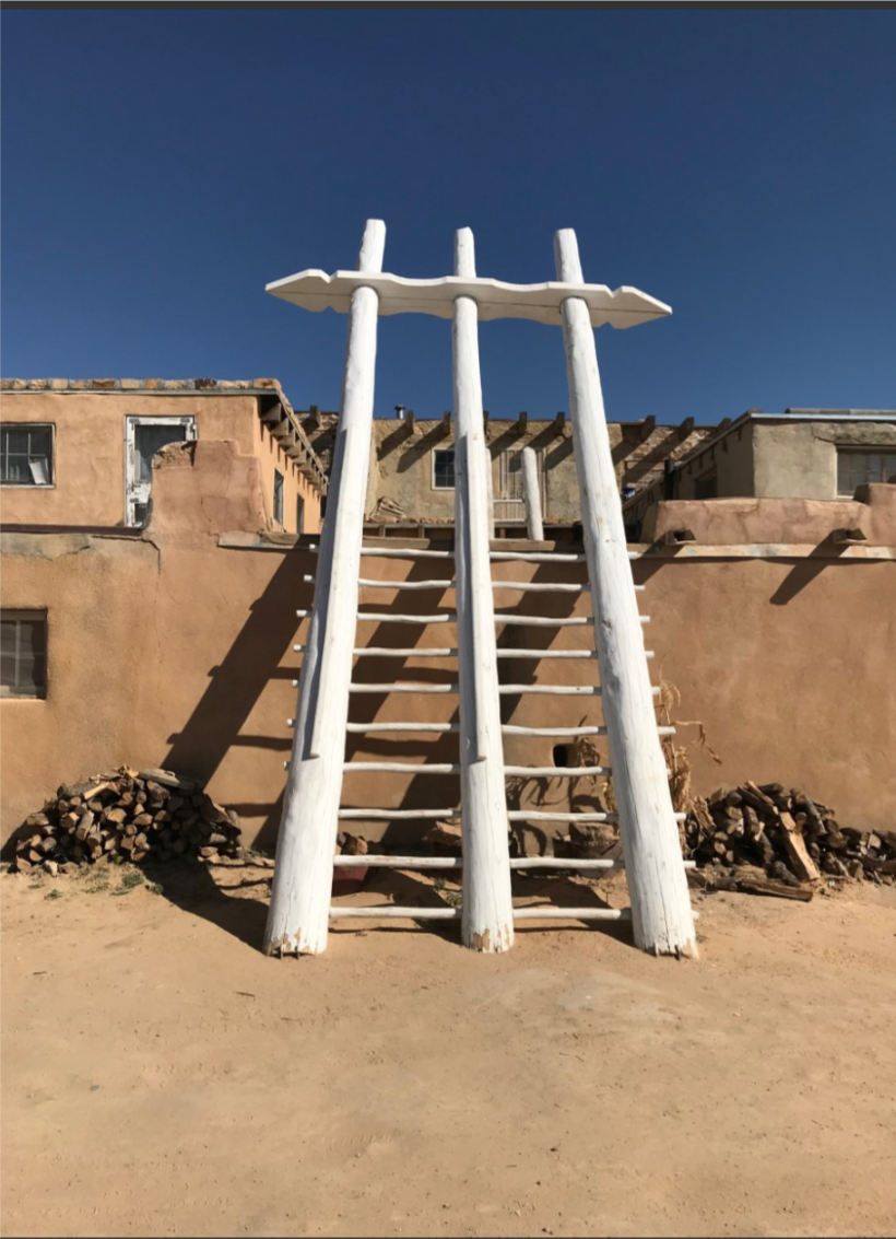

A nice tour.
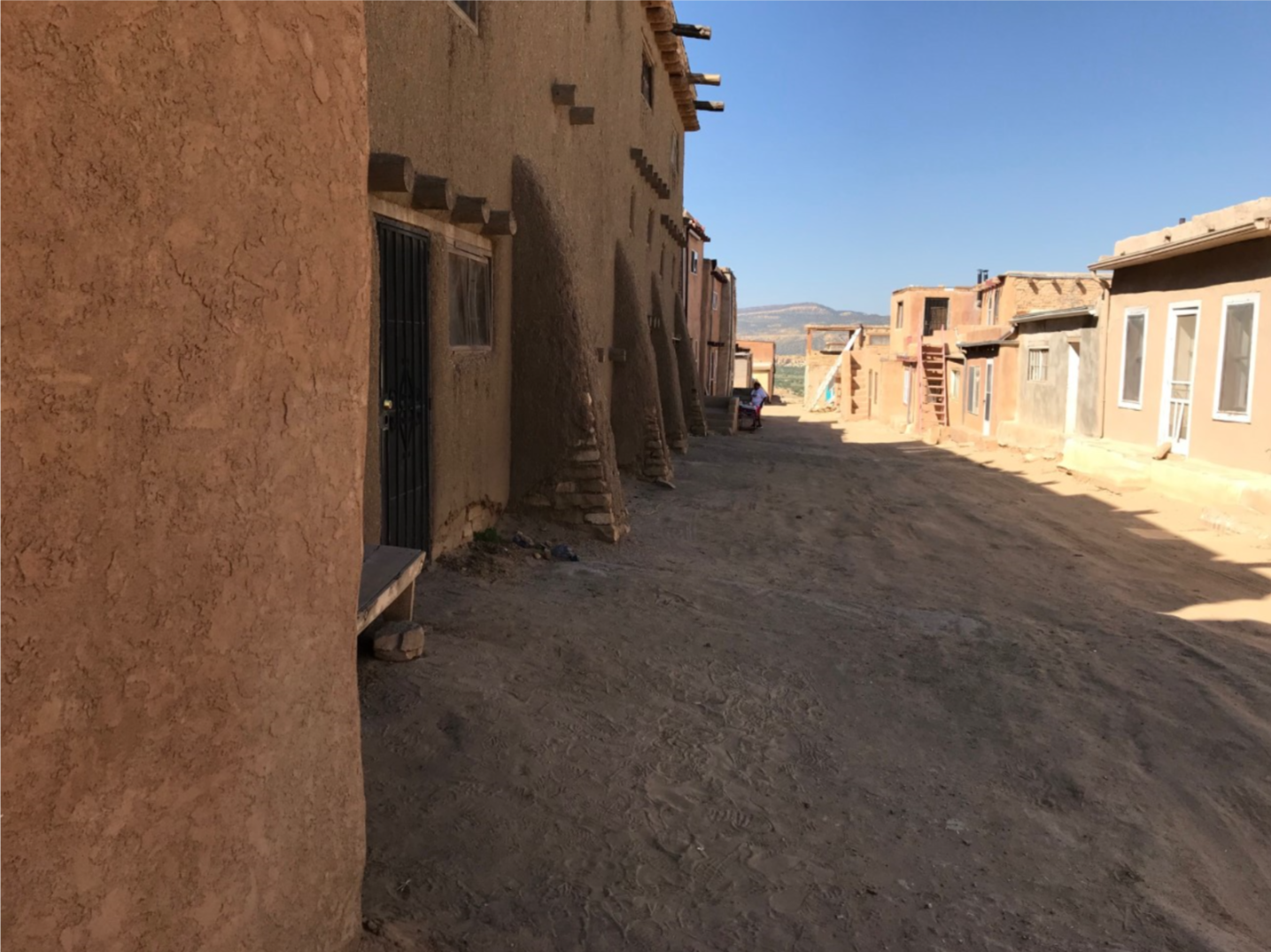
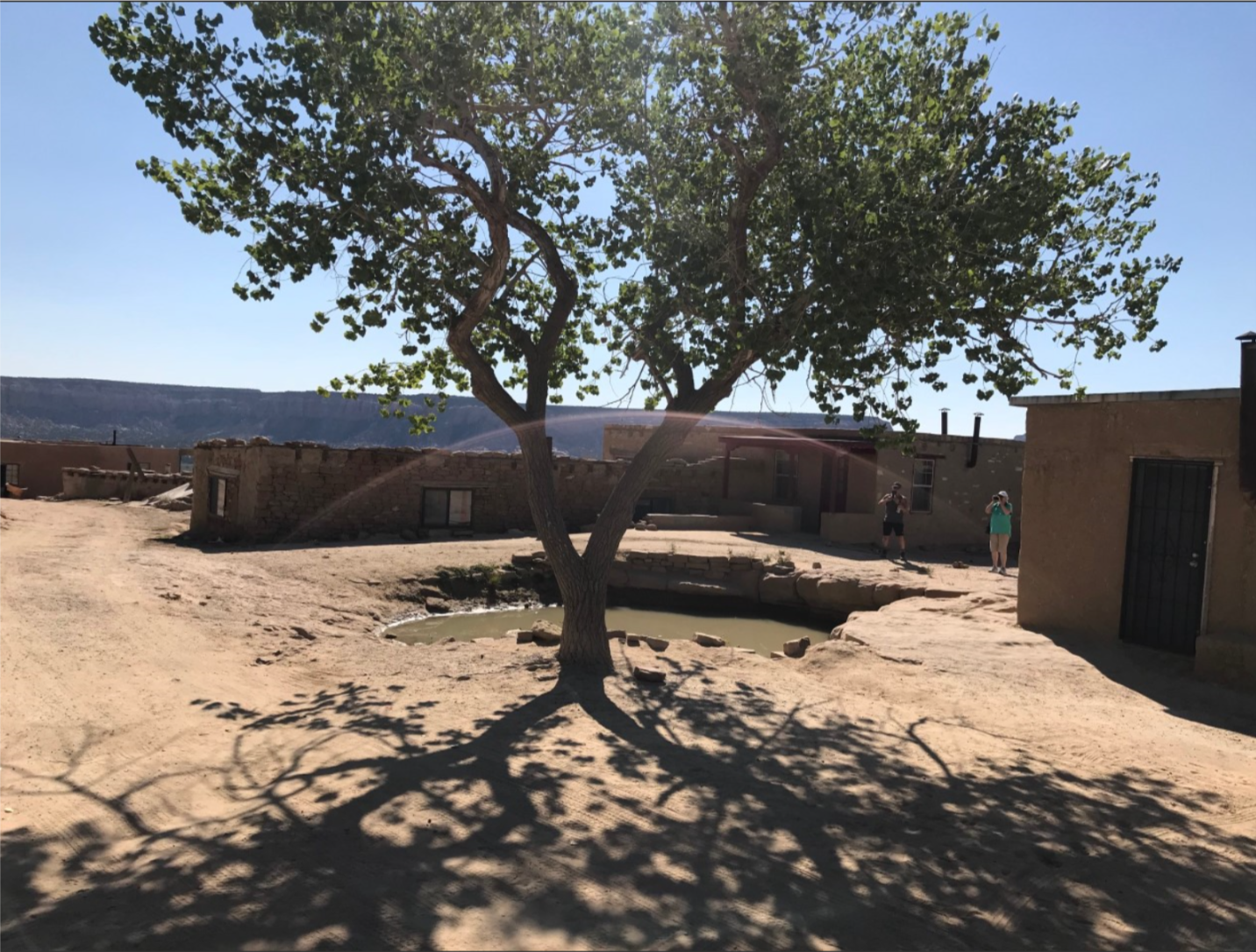
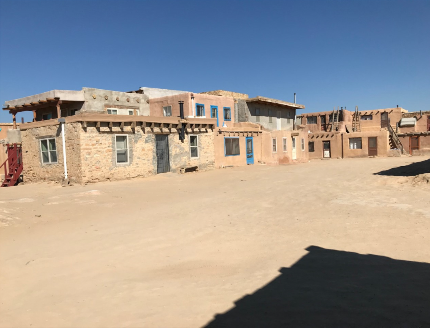
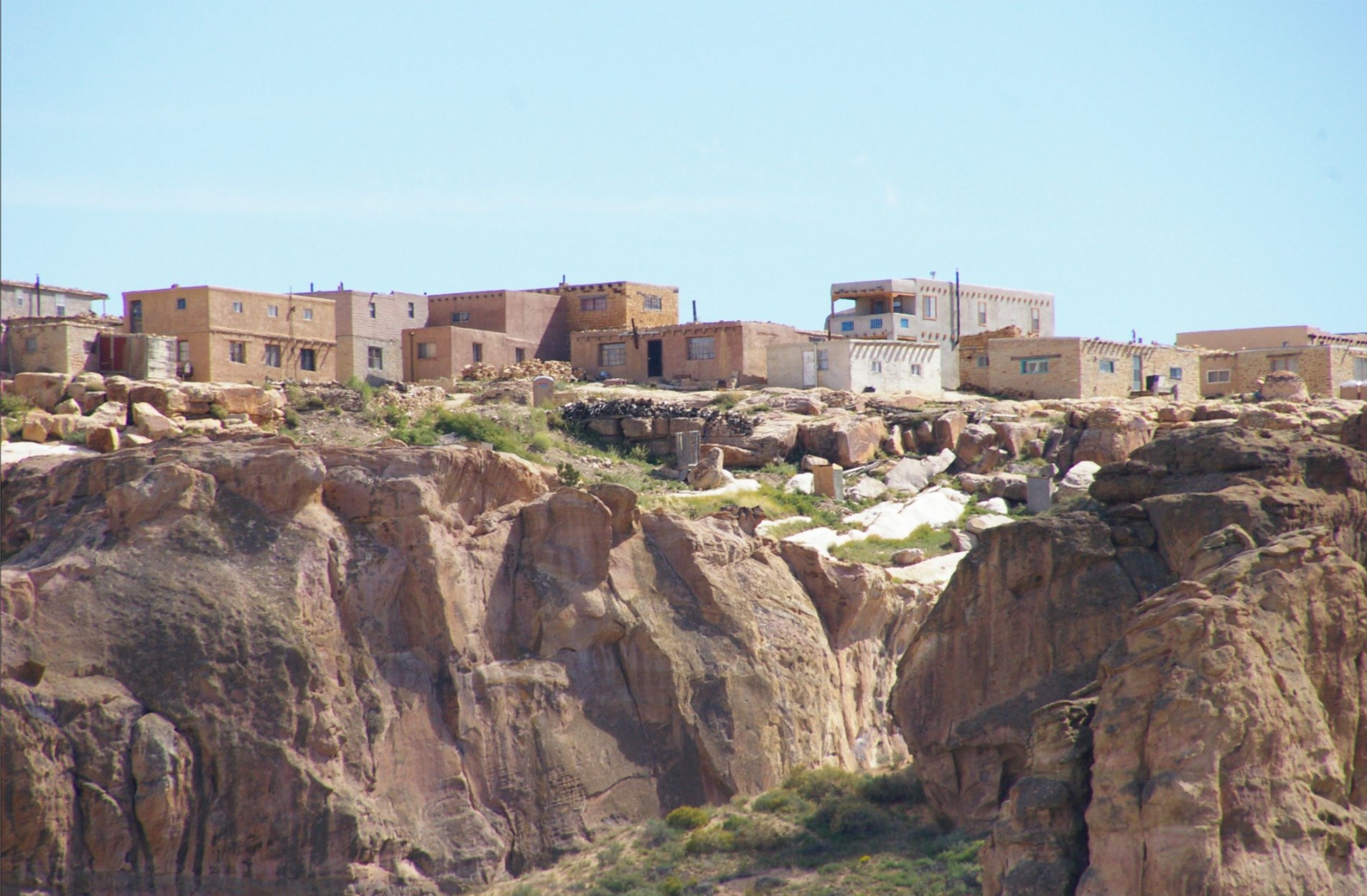
They bused us to the top of the mesa where thirty or so buildings remain.
As many as 30 Acoma people live up here with no water nor electricity.
They keep it as a sort of retreat, to remind themselves of their heritage.
Most of the people live in villages below the mesa.
That tree the guide called their national forest.
It’s hot!
__________________________________________
What follows is a detail of that tribe, taken from Wikipedia, reworked to make it more presentable.
This is a relatively long piece and not for everyone.
Remember that Howard’s piece follows.
looks romantic
but it’s hot and hard
and maintained ceremoniously and not as permanent living quarters for anyone.
_____________________________________________
The English name Acoma was borrowed from Spanish Ácoma (1583) or Acóma (1598).
The Spanish name was borrowed from the Acoma word, 'person from Acoma Pueblo'.
The name does not have any meaning in the modern Acoma language.
Some tribal authorities connect it to the similar word 'preparedness, place of preparedness' and suggest that this might be the origin of the name.
The name does not mean 'sky city'.
Other tribal elders assert that it means 'place that always was' while outsiders say it means 'people of the white rock'.
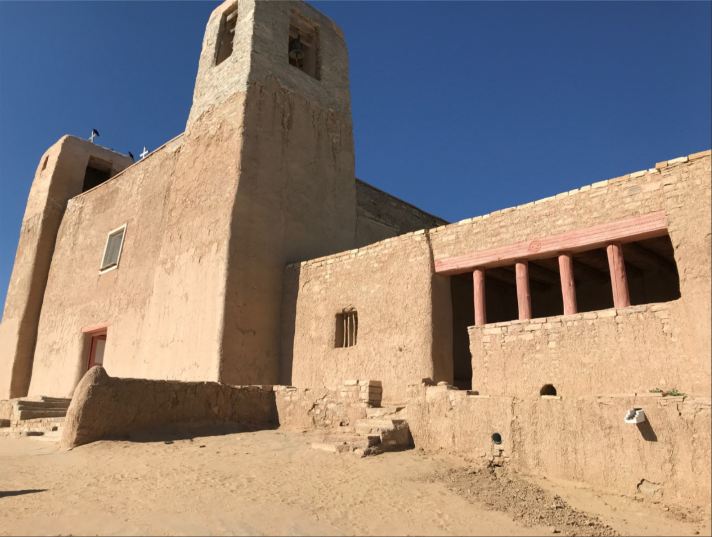
The Spanish mission name was San Esteban de Acoma.
Pueblo is the Spanish word for ‘village’ or ‘small town.’
In general usage, it is applied both to the people and to the unique architecture of the southwestern native tribes.
The Acoma are called ʔáák’u [ʔɑ́ːk'ù] in Western Keresan, Hakukya in Zuni, and Haak’oh in Navajo.
The Acoma language is classified in the western division of the Keresan languages.
In contemporary Acoma Pueblo culture, most people speak both Acoma and English.
Elders were forced to speak Spanish.
Pueblo people are believed to have descended from the Anasazi, Mogollon, and other ancient peoples.
These influences are seen in the architecture, farming style, and artistry of the Acoma.
In the 13th century, the Anasazi abandoned their canyon homelands due to climate change and social upheaval.
For upwards of two centuries, migrations occurred in the area.
The Acoma Pueblo emerged by the thirteenth century.
However, the Acoma themselves say the Sky City Pueblo was established in the 11th century, with brick buildings as early as 1144 on the Mesa indicating as such due to their unique lack of Adobe in their construction proving their antiquity.
This early founding date makes Acoma Pueblo one of the earliest continuously inhabited communities in the United States.
The Pueblo is situated on a 365-foot (111 m) mesa, about 60 miles (97 km) west of Albuquerque, New Mexico.
The isolation and location of the Pueblo has sheltered the community for more than 1,200 years. They sought to avoid conflict with the neighboring Navajo and Apache peoples.
European contact

so beautiful
so beautiful, rarely
it’s hot and dry and very windy
but so beautiful
The first mention of Acoma was in 1539.
Estevanico, a slave, was the first non-Indian to visit Acoma and reported it to Marcos de Niza, who related the information to the viceroy of New Spain after the end of his expedition.
Acoma was called the independent Kingdom of Hacus.
He called the Acoma people encaconados, which meant that they had turquoise hanging from their ears and noses.
Captain Hernando de Alvarado of conquistador Francisco Vázquez de Coronado's expedition described the Pueblo (which they called Acuco) in 1540 as "a very strange place built upon solid rock" and "one of the strongest places we have seen."
Upon visiting the Pueblo, the expedition "repented having gone up to the place."
Further from Alvarado's report:
These people were robbers, feared by the whole country round about.
The village was very strong, because it was up on a rock out of reach, having steep sides in every direction...
There was only one entrance by a stairway built by hand...
There was a broad stairway of about 200 steps, then a stretch of about 100 narrower steps and at the top they had to go up about three times as high as a man by means of holes in the rock, in which they put the points of their feet, holding on at the same time by their hands. There was a wall of large and small stones at the top, which they could roll down without showing themselves, so that no army could possibly be strong enough to capture the village.
On the top they had room to sow and store a large amount of corn, and cisterns to collect snow and water.

Mission San Esteban Rey was built c.1641, photograph by Ansel Adams, c.1941

A view from 2009 of the same building, where architectural modifications are apparent

Fiesta de San Esteban, Acoma Pueblo, ca. 1900
It is believed Coronado's expedition were the first Europeans to encounter the Acoma.
(Estevan was a native Moroccan.)
Alvarado reported that first the Acoma refused entry even after persuasions but after Alvarado showed threats of an attack the Acoma guards welcomed the Spaniards peacefully noting that they and their horses were tired.
The encounter shows that the Acoma had clothing made of deerskin, buffalohide, and woven cotton as well as turquoise jewelry, domestic turkeys, bread, pine nuts, and maize. The village seemed to contain about 200 men.
Acoma was next visited by the Spanish 40 years later in 1581 by Fray Agustín Rodríguez and Francisco Sánchez Chamuscado with 12 soldiers, 3 other friars, and 13 others including Indian servants.
The Acoma at this time were reported to be somewhat defensive and fearful.
This response may have been due to the knowledge of the Spanish enslavement of other Indians to work in silver mines in the area.
However, eventually the Rodríguez and Chamuscado party convinced them to trade goods for food.
The Spaniard reports say the pueblo had about 500 houses of either three or four stories high.
In 1582, Acoma was visited again by Antonio de Espejo for three months.
The Acoma were reported to be wearing mantas.
Espejo also noted irrigation in Acomita, the farming village in the north valley near San Jose River which was two leagues from the mesa.
He saw evidence of intertribal trade with "mountain Querechos".
Acoma oral history does not confirm this trade but only tells of common messengers to and from the mesa and Acomita, McCartys Village, and Seama.
Juan de Oñate intended on colonizing New Mexico starting from 1595.
(He formally held the area by April 1598.)
The Acoma warrior Zutacapan heard of this plan and warned the mesa and organized a defense. However, a pueblo elder Chumpo dissuaded war partly to prevent deaths and partly based on Zutancalpo's (Zutacapan's son) mentioning of the widespread belief that the Spaniards were immortal. Thus, when Oñate visited on October 27, 1598, Acoma met him peacefully with no resistance to Oñate's demand of surrender and obedience reported.
Oñate demonstrated his military power by firing a gun salute.
Zutacapan offered to meet Oñate formally in the religious kiva, which is traditionally used as the place to make sacred oaths and pledges.
However, Oñate was scared of death and in suspicious ignorance of Acoma customs refused to enter via ladder from the roof into the dark kiva chambers.
Purguapo was another Acoma man out of four chosen for Spaniard negotiations.

Acoma water girls by Edward S. Curtis
Gaspar Pérez de Villagrá visited Acoma soon after Oñate's departure by himself with a dog and a horse and asked for other supplies.
Villagrá refused to get off his horse and left to follow after Oñate's party.
However, Zutacapan convinced him to return to receive supplies.
In questioning by Zutacapan, Villagrá said that 103 armed men were two day away from Acoma. Zutacapan then told Villagrá to leave Acoma.
On December 1, 1598, Juan de Zaldívar, Oñate's nephew, reached Acoma with 20–30 men and peacefully traded with them and had to wait some days for their order of ground corn. On December 4, Zaldívar went with 16 armored men to Acoma to find out about the corn. Zutacapan met them and directed them to the homes with the corn. Zaldívar's people then divided into groups to collect the corn. The traditional oral Acoma narrative tells that a group attacked some Acoma women leading Acoma warriors to retaliate.
The Spanish documents do not report an attack on the women and say that the division of the men was a reaction to Zutacapan's plan to kill Zaldívar's party.
The Acoma killed 12 of the Spaniards including Zaldívar.
Five men escaped although one died from jumping over the citadel leaving four to escape with the remaining camp.
On December 20, 1598, Oñate learned of Zaldívar's death and after encouraging advice from the friars planned an attack in revenge as well to teach a lesson to other pueblos.
Acomas requested help from other tribes to defend against the Spanish.
Among the leaders were Gicombo, Popempol, Chumpo, Calpo, Buzcoico, Ezmicaio, and Bempol (a recruited Apache war leader).
On January 21, 1599, Vicente de Zaldívar (Juan de Zaldívar's brother) reached Acoma with 70 soldiers.
The Acoma Massacre started the next day and lasted for three days.
On January 23, men were able to climb the southern mesa unnoticed by Acoma guards and breach the pueblo.
The Spanish dragged a cannon through the streets toppling adobe walls and burned most of the village killing 800 people (decimated 13% of the 6,000 population) and imprisoning approximately 500 others.
The pueblo surrendered at noon on January 24. Zaldívar lost only one of his men.
The Spanish amputated the right feet of men over 25 years old and forced them into slavery for 20 years.
They also took males aged 12–25 and females over 12 away from their parents putting most of them in slavery for 20 years.
The enslaved Acoma were given to government officials and various missions.
Two other Indian men visiting Acoma at the time had their right hands cut off and were sent back to their respective Pueblos as a warning of the consequences for resisting the Spanish.
On the north side of the mesa, a row of houses still retain marks from the fire started by a cannon during this Acoma War.
(Oñate was later exiled from New Mexico for mismanagement, false reporting, and cruelty by Philip III of Spain.)
Survivors of the Acoma Massacre rebuilt their community 1599–1620.
Oñate forced the Acoma and other local Indians to pay taxes in crops, cotton, and labor.
Spanish rule also brought Catholic missionaries into the area.
The Spanish renamed the pueblos with the names of saints and started to construct churches at them. They introduced new crops to the Acoma, including peaches, peppers, and wheat.
A 1620 royal decree created Spanish civil offices in each pueblo, including Acoma, with an appointed governor to take command. In 1680 the Pueblo Revolt took place, with Acoma participating.
The revolt brought refugees from other pueblos. Those who eventually left Acoma moved elsewhere to form Laguna Pueblo.
The Acoma suffered high mortality from smallpox epidemics, as they had no immunity to such Eurasian infectious diseases.
They also suffered raiding from the Apache, Comanche, and Ute.
On occasion, the Acoma would side with the Spanish to fight against these nomadic tribes.
Forced to formally adopt Catholicism, the Acoma proceeded to practice their traditional religion in secrecy, and combined elements of both in a syncretic blend.
Intermarriage and interaction became common among the Acoma, other pueblos, and Hispanic villages. These communities would intermingle in a kind of creolization to form the culture of New Mexico.
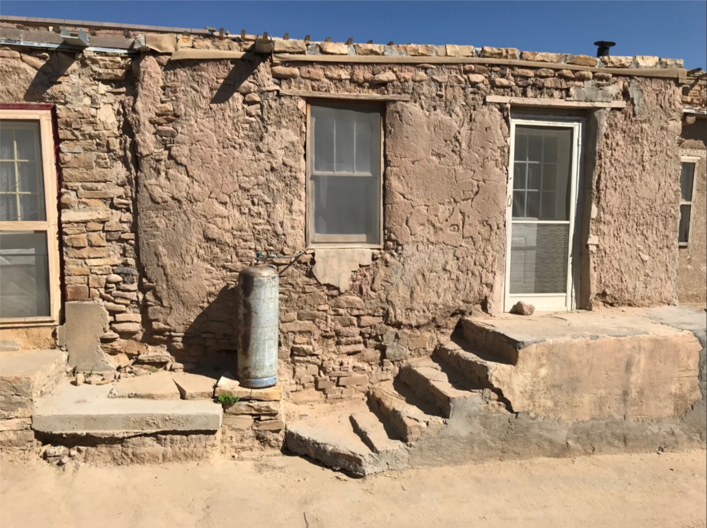
Today, about 300 two- and three-story adobe buildings stand on the mesa, with exterior ladders used to access the upper levels where residents live.
Access to the mesa is by a road blasted into the rock face during the 1950s.
Approximately 30[18] or so people live permanently on the mesa, with the population increasing on the weekends as family members come to visit and tourists, some 55,000 annually, visit for the day.
Acoma Pueblo has no electricity, running water, or sewage disposal.
A reservation surrounds the mesa, totaling 600 square miles (1,600 km2).
Tribal members live both on the reservation and outside it.
Contemporary Acoma culture remains relatively closed, however.
According to the 2000 United States census, 4,989 people identify themselves as Acoma.
Acoma government was maintained by two individuals: a cacique, or head of the Pueblo, and a war captain, who would serve until their deaths.
Both individuals maintained strong religious connections to their work, representing the theocracy of Acoma governance.
The Spanish eventually imposed a group to oversee the Pueblo, but, their power was not taken seriously by the Acoma.
The Spanish group would work with external situations and comprised a governor, two lieutenant governors, and a council.
The Acoma also participated in the All Indian Pueblo Council, which started in 1598 and arose again in the twentieth century.
Today, the Acoma controls approximately 500,000 acres (200,000 ha) of their traditional land. Mesas, valleys, hills, and arroyos dot the landscape that averages about 7,000 feet (2,100 m) in altitude with about 10 inches (250 mm) of rain each year.
Since 1977, the Acoma have increased their domain through several land purchases.
On the reservation, only tribal members may own land and almost all enrolled members live on the property.
The cacique is still active in the community, and is from the Antelope clan.
The cacique appoints tribal council members, staff, and the governor.
In 2011 Acoma Pueblo and the Pueblo of Santa Clara were victims of heavy flooding.
New Mexico supplied more than $1 million to fund emergency preparedness and damage repair for victims and governor Susana Martinez requested additional funding from the Federal Emergency Management Agency.
Historically, engagements in warfare were common for Acoma, like other Pueblos. Weapons used included clubs, stones, spears, and darts. The Acoma later would serve as auxiliaries for forces under Spain and Mexico, fighting against raids and protecting merchants on the Santa Fe Trail. After the nineteenth-century, raiding tribes were less of a threat and Acoma military culture began to decline. The war captain position eventually would change to a civil and religious function.[6]
Acoma Pueblo has three rows of three-story, apartment-style buildings which face south on top of the mesa.
The buildings are constructed from adobe brick with beams across the roof that were covered with poles, brush, and then plaster.
The roof for one level would serve as the floor for another. Each level is connected to others by ladders, serving as a unique defensive aid; the ladders are the only way to enter the buildings, as the traditional design has no windows or doors.
The lower levels of the buildings were used for storage. Baking ovens are outside the buildings, with water being collected from two natural cisterns.
Acoma also has seven rectangular kivas and a village plaza which serves as the spiritual center for the village.
About 20 matrilineal clans were recognized by the Acoma.
Traditional child rearing involved very little discipline.
Couples were generally monogamous and divorce was rare with a quick burial after death, followed by four days and nights of vigil.
Women would wear cotton dresses and sandals or high moccasin boots.
Traditional clothing for men involved cotton kilts and leather sandals.
Rabbit and deer skin was used for clothing and robes, as well.
In the seventeenth century horses were introduced to the Pueblo by the Spanish.
Education was overseen by kiva headmen who taught about human behavior, spirit and body, astrology, ethics, child psychology, oratory, history, dance, and music.
Since the 1970s, Acoma Pueblo has retained control over education services, which have been keys in maintaining traditional and contemporary lifestyles.
They share a high school with Laguna Pueblo.
Alcoholism, drug use, and other health issues are prominent on the reservation and Indian Health Service hospitals and native healers cooperate to battle health problems.
Alcohol is banned on the Pueblo.
The community is served by the Acoma-Canoncito-Laguna (ACL) Hospital run by the Indian Health Services and located in Acoma.
Today, 19 clans still remain active.
Traditional Acoma religion stresses harmony between life and nature.
The sun is a representative of the Creator deity.
Mountains surrounding the community, the sun above, and the earth below help to balance and define the Acoma world.
Traditional religious ceremonies may revolve around the weather, including seeking to ensure healthy rainfall.
The leader of each Pueblo would serve as the community religious leader, or cacique.
The cacique would observe the sun and use it as a guide for scheduling ceremonies, some which were kept secret.
Many Acoma are Catholic, but blend aspects of Catholicism and their traditional religion.
Many old rituals are still performed.
In September, the Acoma honor their patron saint, Saint Stephen.
For feast day, the mesa is opened to the public for the celebration.
More than 2,000 pilgrims attend the San Esteban Festival.
The celebration begins at San Esteban Del Rey Mission and a carved pine effigy of Saint Stephen is removed from the altar and carried into the main plaza with people chanting, shooting rifles, and ringing steeple bells.
The procession then proceeds past the cemetery, down narrow streets, and to the plaza.
Upon arriving at the plaza, the effigy is placed in a shrine lined with woven blankets and guarded by two Acoma men.
A celebration follows with dancing and feasting. During the festival, vendors sell goods such as traditional pottery and cuisine.
Before contact with the Spanish, Acoma people primarily ate corn, beans, and squash.
Mut-tze-nee was a popular thin corn bread.
They also raised turkeys, tobacco, and sunflowers.
The Acoma hunted antelope, deer, and rabbits.
Wild seeds, berries, nuts, and other foods were gathered.
After 1700, new foods were noted in the historical record.
Blue corn drink, pudding, corn mush, corn balls, wheat cake, peach-bark drink, paper bread, flour bread, wild berries, and prickly pear fruit all became staples.
After contact with the Spanish, goats, horses, sheep and donkeys were raised.
In contemporary Acoma, other foods are also popular such as apple pastries, corn tamales, green-chili stew with lamb, fresh corn, and wheat pudding with brown sugar.
Irrigation techniques such as dams and terraces were used for agricultural purposes.
Farming tools were made of wood and stone.
Harvested corn would be ground with hands and mortar.
Historical Acoma economic practices are described as socialistic or communal.
Labor was shared and produce was distributed equally.
Trading networks were extensive, spreading thousands of miles throughout the region.
During fixed times in the summer and fall, trading fairs were held.
The largest fair was held in Taos by the Comanche.
Nomadic traders would exchange slaves, buckskins, buffalo hide, jerky, and horses.
Pueblo people would trade for copper and shell ornaments, macaw feathers, and turquoise.
The Acoma would trade via the Santa Fe Trail starting in 1821, and with the arrival of railroads in the 1880s, the Acoma became dependent on American-made goods.
This dependency would cause traditional arts such as weaving and pottery making to decline.
Today, the Acoma produce a variety of goods for economic benefit.
Agriculturally they grow alfalfa, oats, wheat, chilies, corn, melon, squash, vegetables, and fruit.
They raise cattle and have natural reserves of gas, geothermal, and coal resources.
Uranium mines in the area provided work for the Acoma until their closings in the 1980s.
After that, the tribe provided most employment opportunities.
However, high unemployment rates trouble the Pueblo.
The legacy of the uranium mines has left radiation pollution, causing the tribal fishing lake to be drained and some health problems within the community.
TOURISM
Tourism is a major source of income for the tribe.
In 2008 Pueblo Acoma opened the Sky City Cultural Center and Haak'u Museum at the base of the mesa, replacing the original, which was destroyed by fire in 2000.
The center and museum seek to sustain and preserve Acoma culture.
Films about Acoma history are shown and a café serves traditional foods.
The architecture was inspired by pueblo design and indigenous architectural traditions with wide doorways in the middle, which in traditional homes make the bringing of supplies easier,
Flecks of mica are in the windowpanes, a mineral which is used to create mesa windows.
The complex is also fire resistant, unlike traditional pueblos, and is painted in light pinks and purples to match the landscape surrounding it.
Traditional Acoma artwork is exhibited and demonstrated at the Center, including ceramic chimneys crafted on the rooftop.
Arts and crafts also bring income into the community.
Acoma Pueblo is open to the public by guided tour from March thru October, though June and July have periods of closure for cultural activities.
It is advisable for visitors to call ahead to confirm whether they are open or not.
Photography of the Pueblo and surrounding land is restricted.
Tours and camera permits are purchased at the Sky City Cultural Center.
While photography may be produced with permit, video recordings, drawings, and sketching are prohibited.
The Acoma Pueblo also has a casino and hotel - the Sky City Casino Hotel.
The casino and hotel are alcohol-free and are maintained by the Acoma Business Enterprise which oversees most Acoma businesses.
ART
Acoma pottery dates back to more than 1,000 years ago.
Dense local clay, dug up at a nearby site, is essential to Acoma pottery.
The clay is dried and strengthened by the addition of pulverized pottery shards.
The pieces then are shaped, painted, and fired.
Geometric patterns, thunderbirds, and rainbows are traditional designs, which are applied with the spike of a yucca.
Upon completion, a potter would lightly strike the side of the pot, and hold it to their ear.
If the pot does not ring, then the pot will crack during firing. If this was found, the piece would be destroyed and ground into shards for future use.
—————————————-
That’s it for today, my friends.
Manana.
__________________________

Climbing the rockface of “Le Rocher” to examine the caves of Cotignac, France.
______________________________________
Water and time are almost all that are needed. These elements force changes, imperceptible to start, in equally elemental materials, like sand and trace minerals; produce wondrous results after long periods passing over both. One result, on a gargantuan scale, can be the Grand Canyon – nearly 300 miles long and more than a mile deep. The mundane terminology belies the effects: it’s simply the erosion of rocks by continuously running water over a period of an inconceivable number of years.
Simple enough. And there is nothing I could say that would amplify the effects of the visual evidence. Nevertheless, I would suggest there are other equally natural and fundamental changes evidenced, requiring even closer looks. The artifacts of erosion are clear, one might say obvious. Other effects, collateral effects of processes that require perhaps even longer shifts in time, contribute to the dazzling vision.
I am talking about the striae (the more common term is striations) of color that in the totality of a view, or even the most pedestrian photographic record, induce such a powerful mix of wonder and pleasure. In the most subtle and inseparable of differences one layer to the next, shades of yellow and red and brown, or in more seemingly precise terminology, of ochres, and umbers, and siennas intermingle and leap and bound over and under and through one another.
The chemist or geologist will speak precisely of the oxides of iron underlying the coloration. Glauconite, and its cousins once and twice removed, hematite and limonite and likely at least a dozen other -ites lend subtleties of tone and hue to the rock. By most accounts, it is the action of over two billion years of the Colorado River that resulted in the Grand Canyon. Colorado, the name and the word, are from the Spanish, and can mean, variously, the color red, or simply that any object or subject so described, as “colorado,” is “colored red.” Is, in effect, showing a perpetual blush.
It happens the word is used as well, usually in a technical context, to describe the rock formations in large portions of Southern Europe, and France in particular. “Colorado provençal” refers to the ochre, not the mere color, but the rock, the substance, and the pigment derived from it, of the prevailing formations in that part of France that goes by the same name: Provence. Except it was only a hundred million years ago, a mere moment compared to the age of the Grand Canyon, that the hills and mountains and gorges of the South of France were under water, under the great sea that divided Africa from Asia: the Tethyan ocean. And as that sea eventually divided, culminating in the formation among other things of the Atlantic Ocean, and the emergence of the land mass we call Europe, it also was generating limestone—as all great seas do, being rock factories, combining chalk with minerals.
The Cretaceous period of geologic time, just following the Jurassic, saw the making of the hills ginned up of calcareous rock, to be quarried millions of years later to make the rude homes of our ancestors, not only in Europe, but elsewhere. And in time, time we measure as modern and civilized, the rude homes gave way to ever more elegant and grandiose dwellings, as well as fortresses. The castles and forts of the Loire Valley in France, celebrated in fable and still the stuff of fairy tales, were built of that limestone, also used to make the far more humble huts and grain stores and commercial dens of the common citizenry. The stone, quarried for over 800 years, starting in the 11th century, from over 1000 kilometers of galleries riddling the earth, was the prime material for thousands of structures, many still standing.
The native stone was ideal for construction as it was strong and more resistant to the elements than other deposits of chalk-based rock from the Cretaceous, yet not so tough that it could not be quarried readily or permit intricate carving. It was perhaps the excellence of the materials native to their land that made the French, including the Normans, well to the northwest of the Loire, famous for their masonry, as well as for the quality of the natural materials.
It was a Norman king of course, William, who effected the only defeat of English forces on their own soil, that led to the use of French stone in the construction of a great deal of early London, which is founded on land that provides no natural building materials, save for sand and mud. The proximity of the Thames River made for easier transport of good Norman “Caen stone,” also a sturdy workable stone, whiter than the more typical grey stone of the Loire region. It was Caen stone that William exploited for the construction of the most famous (and enduring) symbol of his conquest, the Tower of London, which loomed, at 90 feet, as the monstrous testament to his power over the countryside, as well as dwarfing the modest one and two-story erections that populated most of London. William built his tower at about the same time as the start of the great boom of construction of nearly a thousand years in the Loire.
To the south, as I started to say, the natural ochre deposits, along with related minerals, tinted the equally pliant but durable limestone that makes up the great massifs that overlook the Mediterranean. The stone in Provence and well into the southwest, also Cretaceous, is imbued with a honey-colored hue, which seems to deepen in the perpetual sunshine of the region. It is the natural building material of the South to the extent that even today, it is the preferred material for authenticity of the sometimes modest, sometimes palatial rural homes of wine country and of the foothills of the Alps. The range of the characteristic architecture of the humble free-standing mas, as the Provençal name of the farmhouse, with its origins in the huts of the late middle-ages, extends from the Pyrenées to the southwest and along the coast and inland hills all the way to the frontier near the Italian border.
The homes are reminiscent, given their ruddy hew, especially as the sun lowers over the peaks of famous elevations that inspired the great post-Impressionist painters, Mount Saint-Victoire and Mount Ventoux, of the complex villages among the craggy hills of the American southwest – the pueblos of New Mexico, Arizona, and, of course, further south. Some of these latter settlements have been continually inhabited for over 2,000 years. These are exceptions, as there was a diaspora of pueblo residents, that occurred further to the west and much further south, deep into Mexico, and between the 13th and 15th centuries untold thousands of pueblo dwellers abandoned their homes and left them that way. Any definitive cause for the dispersion remains elusive.
Similarly, and wholly coincidentally, though the causes are better known, including famine, plague, and, much earlier on, the vagaries of conquest of the region by Saracens, which was the vernacular for Muslim invaders and conquerors from the East. It’s well-known, I believe, that the Moors vanquished the Spanish in the 8th century and it took another 400 years for them to be driven out. Sporadically, as is germane to this particular story, the Caliphate attempted to spread across the Pyrenées into the south of France. They were repulsed in 732 AD by Charles, the Frankish king who adopted the name by which he was known, that of “Martel” (the hammer), but attempts by the Muslims persisted into the 10th century to reclaim the territories from which he drove them so forcibly.
Even farther to the east of the Luberon, the region that the successors to Charles Martel defended effectively (mostly, though they never entirely drove the Muslims from what is modern Narbonne, a stronghold port on the Mediterranean, and west of Provence, but an effective staging area for raids well into southeastern heart of Provence), there are small villages, with which I am well familiar. Among others, there are Cotignac and Villecroze, picturesque towns defined by the hills into which they have embedded themselves. Among their attractions are their most striking physical features: troglodyte caves set into rock walls that rise precipitously from the plain at the foot of them where the calm and mostly gentle (these days) way of life proceeds undisturbed. The grottoes of Villecroze form one boundary of a bucolic, beautifully landscaped park, a reliable respite for natives and tourists, and feature some still active cascades. If you brave the winding climb to the caverns high in the rock, at one point you can walk behind one waterfall; quite refreshing. The water is a reminder of that natural forces that over the course of a hundred million years formed the shallow caverns as well as the deeper chambers that form a natural habitat.
These were, in fact, inhabited intermittently since they were formed in their current state by the last ice age, 700,000 years ago. Such hardy individuals are called “troglodytes,” literally, “cave-divers.” And they have returned intermittently to take refuge, especially in numbers in the 10th century, during the last serious attempt at conquest by the Saracens from the west.
Similar incursions precipitated similar refuge-seeking in the neighboring village of Cotignac, which has, if anything, even more impressive vestiges of the former cave-dwellings, which the most intrepid tourists can examine and inspect if they are hardy enough. There are even vestiges at the top of the incredibly steep rock-face, in which the caves are located, of the two towers – still known as the Saracen towers (“les tours des Sarassines”), not for their builders, but for their purpose, to be on the lookout for the “barbarian” invaders.
But a further contemplation of the troglodyte caves and rockface of Cotignac will arrive in the next installment.—Howard Dinin. © 2018.

Cave entrance, with 19th century graffiti scratched on the surface.